
Tuesday, December 2, 2014
Sunday, August 10, 2014
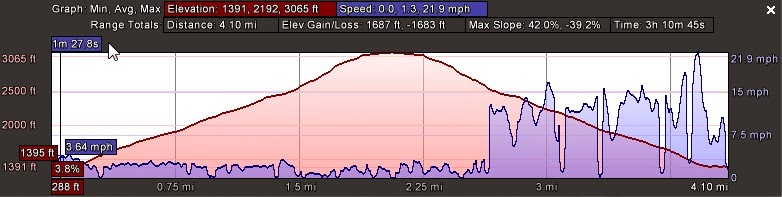
Skyline Traverse
A while back, Huff and I threw around the idea of doing a traverse of the local Skyline Trail in Blue Hills Reservation. While not exactly alpine, the Skyline can be salvation for we city folk looking for a bit of adventure on a tight schedule. The trail runs the length of the reservation, tackling the majority of the elevation therein. Our schedules lined up a week ago and we decided to give it a go. Huff is in the midst of prepping for a 50 mile race, so I was a bit nervous that I'd have a hard time keeping up given my minimal training. In the end I was able to keep up for most of the day, though around mile 13 my legs decided they'd had enough and it was slow going for the final leg of the trip. Nevertheless, we enjoyed the chance to put in some miles on trail so close to home, venturing into a part of the reservation I had yet to explore.


Tuesday, August 5, 2014
Baxter State Park
Since we first started adventuring in the outdoors over a decade ago, my father has been sharing his dreams of traveling to Baxter State Park in order to climb Mt. Katahdin. We've attempted to put this together a few times over the past few years but due to commitments, vacation schedules, and other such life events, it never came to fruition. As luck would have it, this year we had a perfect window with my brother Will home from the west coast, my dad on summer break from teaching (lucky), and my research being at a forgiving position. With the good fortune in hand, we made the trek up north to Millinocket, ME for a weekend of wilderness fun.
While we had originally planned to hike the Knife's Edge from this point, our time was running short on the day and with everyone feeling the climb a bit, we made the decision to descend via the Helon Taylor trail out to Roaring Brook. Talking with a few folks who had come the other direction confirmed our decision - the Knife's Edge would have been at least a two hour affair for our group, and we we'd have quite the distance to cover even after we finished. We enjoyed a casual, albeit lengthy, runout down the Taylor trail capping off a day of fun and some challenging hiking.
It was great to be able to get out with my dad and brother, the two people with whom I started adventuring into the backcountry. Even though real life has prevented the three of us from sharing in our love of the outdoors as much as we'd like, we are lucky to have chances like this one to see new places and take on new challenges. Needless to say, Baxter and Katahdin were an experience worth the trip and then some. I'm already thinking about getting back up to explore the area more and tackle the remainder of the mountain


For those who are thinking about the trip, some notes we learned while we were up there:
1. Hiking from Roaring Brook to Chimney and across the Knife's Edge is a long day. We weren't moving very fast, but even those who did probably had an 8 hour day at the least. If you go up or down Helon Taylor in one direction this makes it a bit shorter, time-wise. Probably the easiest route is to head up Helon and down Saddle, or the opposite.
2. If you're looking for an adventure, Cathedral and Dudley are both "all-terrain" trails that will have you scrambling and perhaps climbing at points. Cathedral is up only, so if you want to do both, make sure to head up that direction.
3. The best bet is to stay at Roaring Brook (or hike in to Chimney Pond a day early), but if you can't just make sure you get past the main gate by 6:00AM and you should be able to secure parking. The roads are slow, so be sure to budget time accordingly.
 |
| Ginger wanted to come with. |
Of the group, I was the only one who had ever traveled to Baxter, though my experience was quite limited. My sole visit to the park came the morning before a wedding - turns out a friend of Heather's grew up in Millinocket and she and her husband decided to get married on the lake which shares the same name. Heather and I unknowingly strolled into the park around 9:30 with hopes of climbing to Chimney Pond, only to be informed that the line for the waiting list started about 4 hours previously. Shaking off the blow from the man at the desk, we decided to do a quick day hike around Kidney Pond and up Sentinel Mountain, which turned out to be the perfect amount of time before having to don our monkey suits and join in the evenings events.
Going on this previous experience, I was keen to get reservations at a camp ground that would enable our trio to climb the mountain. We reserved a spot of Abol only to find out later that Abol trail had closed for the season (this was a blessing in disguise, from what I've gathered since visiting the park.) Thus, we opted to get a sunrise start and head to Roaring Brook campground, with the intent of ascending the ridge and hiking the famous Knife's Edge.
Our original intent was to climb the Helon Taylor trail to Pomola, then cross the Knife's Edge and descend via the Saddle trail, however, the man in the information cabin suggested a different route - to Chimney Pond, then up Dudley to Pomola and descending the Saddle and out through Chimney Pond again. Given this was as much beta as we were going to get, we opted to trust the kind man and altered our plans accordingly.
.jpg)
The hike in to Chimney Pond is worth the trip alone. It's a steady climb of ~1500ft, but there are several vistas along the way with classic views of the mountain and the surrounding area. In addition, Chimney Pond itself is a natural masterpiece, with sharply rising cliff faces surrounding the mountain water. As someone continually amazed by the beauty of nature, I had no trouble soaking in what Baxter had to offer.
After a brief stop for a mid-morning snack, we headed out to take on Dudley. Looking at the map, I had a feeling this trail would be tough - it covers some substantial vertical in a short distance. Certainly we had our work cut out for us to get to Pomola peak. What we later came to realize is that the bulk of the Dudley trail is small boulder problems, aptly described as "four wheel drive" hiking by a passerby. We spent the next few hours scrambling on all fours through the fields of stone.
Dudley spits out to the top of Pomola peak - the eastern peak of Mt. Katahdin. From here, the Knife's Edge continues west to Baxter Peak, the true summit. The peak boasts views of the eastern side of Mt. Katahdin with Chimney Pond below, as well as an endless sight toward the north, east and south of Baxter, Millenocket and beyond. We gladly took our time to rest up here, have some lunch, and talk to the folks coming the opposite direction along the Knife's Edge.
 |
| Our home for the weekend. |
The hike in to Chimney Pond is worth the trip alone. It's a steady climb of ~1500ft, but there are several vistas along the way with classic views of the mountain and the surrounding area. In addition, Chimney Pond itself is a natural masterpiece, with sharply rising cliff faces surrounding the mountain water. As someone continually amazed by the beauty of nature, I had no trouble soaking in what Baxter had to offer.
 |
| Chimney Pond |
 |
| View from the early part of Dudley |
 |
| Dad showing the boulders he means business. |
 |
| The original hiking crew atop Pomola. |
 |
| Baxter Peak |
 |
| Will and Dad, looking North on our way down. |
 |
| Not bad for an old guy. |
 |
| Will capturing some nature on the way out. |
For those who are thinking about the trip, some notes we learned while we were up there:
1. Hiking from Roaring Brook to Chimney and across the Knife's Edge is a long day. We weren't moving very fast, but even those who did probably had an 8 hour day at the least. If you go up or down Helon Taylor in one direction this makes it a bit shorter, time-wise. Probably the easiest route is to head up Helon and down Saddle, or the opposite.
2. If you're looking for an adventure, Cathedral and Dudley are both "all-terrain" trails that will have you scrambling and perhaps climbing at points. Cathedral is up only, so if you want to do both, make sure to head up that direction.
3. The best bet is to stay at Roaring Brook (or hike in to Chimney Pond a day early), but if you can't just make sure you get past the main gate by 6:00AM and you should be able to secure parking. The roads are slow, so be sure to budget time accordingly.
Monday, July 28, 2014
Firescrew, Mt. Cardigan
This is a rather delayed posting of a trip we took back in March on Mt. Cardigan. Having visited the area last year and taken on the prime packed powder (tongue-in-cheek) on the Alexandria Trail, this year we opted for the Duke trail, which heads up the more northerly Firescrew peak. Visions of this route from the trip last year indicated that, given enough snow, there was potential for some open, snow-field skiing. Fortunately, Mother Nature had granted us with a fair amount of snow. Unfortunately, it had gone through a nice melt-freeze and covered the entire snowpack with a skating-rink of ice. Nevertheless, we managed to summit and enjoy a pleasant lunch in the warm spring sun before slipping down the mountain. Here are some pics from our trip.


 |
| Shoulda packed the hockey equipment... |
 |
| Great view of Cardigan peak. Good skiing in the right conditions. |
 |
| Huff enjoying some recovery nutrition. |
Cardigan looks to be a go-to spot in the future. It's within a reasonable driving distance and easy on the legs going up, with some solid skiing if there's powder. Looking forward to several weekend mornings here in the coming year.
Tuesday, February 18, 2014
Mt. Moosilauke
Following the brutal January doldrums, we finally got back on track with a string of classic winter storms. A brief discussion for a day trip landed on Mt. Moosilauke. We collected some info from various sources, and decided it would be a decent trip to attempt given the accumulations around the area and our interests in a new-to-us tour.
Moosilauke is draped in a long tradition of skiing, verging back on the Dartmout Outing Clubs early days. If you're interested in reading more about it, both the DOC and Goodman's book have a nice summary of the rich ski culture surrounding the mountain. It's so well known, that a less-than-outdoor inclined Dartmouth alum excitedly said to me "That's Dartmouth's mountain!" at the mere mention of it's name. From our perspective, this seemed like a reasonable day tour, and despite it's 10+ mile distance, the total vert would be more than manageable.
In order to access the mountain in the winter, one must park either at the entrance to the Ravine Lodge road or at the base of the Carriage Road. Either way, there's a decent flat run in before you start hitting contours. Having parked and geared up at the Ravine road, we headed out on the 1.5 mile in-route toward our objective. It was obvious from the line of cars, as well as the well packed skin track that we weren't the first to have this idea after the recent storms.
 |
| Ravine Road |
 |
| Posing with Moosilauke in background |
 |
| Carriage Road action shot |
 |
| Gnarly summit |
 |
| Cotton and Huff. It was windy. |
As with any trip, good planning is important. We had agreed to take our aforementioned route up with the hope of descending via Gorge Brook trail. Despite the best of intentions, some outdated maps and faulty information from some other travelers led to a rapid change of plans. Turns out, we missed the trailhead at the summit by about 10m (see GPS below). Given that had at least scouted our previous route on the way up (and knew where it was!), we headed back down the way we came.
 |
| Just missed it. |
The ski down was pleasant, although far from noteworthy. The Carriage Road is almost wide enough to put some turns together, but it never quite gets there. Quick feet and the occasional snowplow are the name of the game. Once on the Snapper, it's true survival skiing. I kept Cotton just barely in sight ahead of me in an effort to prevent any impact if he stopped short around a corner. Despite the narrow path, it was a fun trip down to the Ravine Lodge. We realized we'd need to skin back up to make the trip back to the car easy. In the transition, we ran into a couple and their nice puppy, who apparently had lost his leash on the trek uphill. Fortunately, Huff keeps 30 feet of paracord in his pack at all times and was able to fashion a leash for them. Unfortunately, he didn't offer to have the dog pull us back to the car in return. Needless to say, they were grateful nonetheless.
 |
| This looks familiar... |
While the ski trails may not rival some others we've explored, certainly this is a great trip. And we learned a few lessons: double check to make sure you have updated maps (USFS are apparently more current than USGS) and you can't rely on others to guide you to the trail. If one considers it more of a ski mountaineering objective, it's well worth the effort - a trip up Moosilauke puts you above 4000ft on a classic New England summit with incredible views in all directions. Hopefully next time there's a bit more snow to enjoy once we're up there.
Summary:
 |
 |
Thursday, January 9, 2014
Thunderbolt
Given the recent fortune of fresh snow falling throughout Massachusetts, the usual suspects made a game-time decision to head out to the Berkshires and sample what Mt. Greylock had to offer. The recent storm left the Boston area shut down, with some suburbs getting over 2 feet of light-weight fluff. Native Vermonter Huffman commented on the ridiculousness of the city's shutdown, but I didn't hear him complaining about his "forced" day off.
Unfortunately, the western part of the state didn't luck out quite as much, recording approximately 8 inches of good stuff. With the recent fluctuations in weather, we weren't exactly sure what to expect as far as snow cover was concerned. Nevertheless, with Cotton's newlywed bride Pearl offering us a place to stay at her family's house, it was hard to pass up on the adventure. Better yet, we were graced with a fantastic dinner and some fine local ales to fuel our legs the night before our first official tour of the season. Proximity to mountains and delicious food - can one ask for better hospitality?
The pre-dawn departure was met with brutal cold. I think we recorded a -17F while driving up to N. Adams from Canaan. Otherwise the weather couldn't have been better (I say this only partly tongue-in-cheek), the sky was clear and the sun was shining. I sniped a quick shot through the car window of the sunrise, which never ceases to impress me.

While I've backpacked around Greylock a few times, I've never visited it in the winter, and was excited to revisit one of my first explorations into outdoor adventure. Additionally, the history of the trail and it's ski culture speaks for itself. The Thunderbolt Ski Runners maintain the trail and host an annual race, which involves both a hike to the summit and a timed race downhill. From what I read, the course record of just over 2 minutes was set in the first half of the 20th century, and stands to this day.
By the time we parked and geared up, the weather had warmed up to a balmy -6F, and we were off. Our early morning departure may have been cold, but the lack of skintrack in front of us was a worthy reward. Some remnants of a visitor from the true powder day one day earlier were enough to guide us up the trail, along with some questionable map reading by yours truly.


The trip up is rather pleasant. The start of a trail is just that, a trail about one person wide, and follows along the bank of Hoxie Brook before ascending the eastern face of the mountain. Once the vertical starts to kick in, the trail opens up to a comfortable 20ish feet of skiable width. Thinking back to my first trip out to Cannon last year, my legs and lungs were in much better shape for this season. Turns out experience matters. Nevertheless, we didn't meet the 2 hour ascension time that "someone in shape" can accomplish this tour.

As far as the down goes, Thunderbolt has a lot to offer. Wide enough to string together turns, with many changing pitches and bends. It's a lot of fun, even if you're competing with the limited snowpack and numerous hidden obstacles as we were. We were graced with some powder turns met with the occasional scrape of a rock underfoot. At least two of us lost a ski to a root at some point on the way down, but it's a small trade-off for the fresh snow. During the descent, we passed at least 15 (or 57, if Huff is counting) people who were on their way uphill. Guess we picked the right time to hit the trailhead.
Thunderbolt will certainly require another (or multiple) visits this season, especially if we are graced with a bit more snow. Thankfully, Pearl has extended an invitation for us to return, so hopefully we can realize this goal. Thanks again to our hosts for a great time and some needed coffee for the ride home. Unfortunately, as I write this we're staring in the face of another January thaw. Only in New England can we have subzero temps followed by a 50 degree weekend. Keep your fingers crossed it doesn't last too long.


Unfortunately, the western part of the state didn't luck out quite as much, recording approximately 8 inches of good stuff. With the recent fluctuations in weather, we weren't exactly sure what to expect as far as snow cover was concerned. Nevertheless, with Cotton's newlywed bride Pearl offering us a place to stay at her family's house, it was hard to pass up on the adventure. Better yet, we were graced with a fantastic dinner and some fine local ales to fuel our legs the night before our first official tour of the season. Proximity to mountains and delicious food - can one ask for better hospitality?
The pre-dawn departure was met with brutal cold. I think we recorded a -17F while driving up to N. Adams from Canaan. Otherwise the weather couldn't have been better (I say this only partly tongue-in-cheek), the sky was clear and the sun was shining. I sniped a quick shot through the car window of the sunrise, which never ceases to impress me.
While I've backpacked around Greylock a few times, I've never visited it in the winter, and was excited to revisit one of my first explorations into outdoor adventure. Additionally, the history of the trail and it's ski culture speaks for itself. The Thunderbolt Ski Runners maintain the trail and host an annual race, which involves both a hike to the summit and a timed race downhill. From what I read, the course record of just over 2 minutes was set in the first half of the 20th century, and stands to this day.
By the time we parked and geared up, the weather had warmed up to a balmy -6F, and we were off. Our early morning departure may have been cold, but the lack of skintrack in front of us was a worthy reward. Some remnants of a visitor from the true powder day one day earlier were enough to guide us up the trail, along with some questionable map reading by yours truly.
The trip up is rather pleasant. The start of a trail is just that, a trail about one person wide, and follows along the bank of Hoxie Brook before ascending the eastern face of the mountain. Once the vertical starts to kick in, the trail opens up to a comfortable 20ish feet of skiable width. Thinking back to my first trip out to Cannon last year, my legs and lungs were in much better shape for this season. Turns out experience matters. Nevertheless, we didn't meet the 2 hour ascension time that "someone in shape" can accomplish this tour.
 |
| Brrrrr |
We enjoyed a beer and the classic mountain meal of hard meats and cheeses in the warming hut up top. This is a nice feature, espcially on a cold and windy day. There are even two wood stoves with which to make a cozy atmosphere, if one was so inclined. A DCR worker stopped in to drop off some trash bags and we chatted with him for a bit, then deskinned and headed down the way we came.
As far as the down goes, Thunderbolt has a lot to offer. Wide enough to string together turns, with many changing pitches and bends. It's a lot of fun, even if you're competing with the limited snowpack and numerous hidden obstacles as we were. We were graced with some powder turns met with the occasional scrape of a rock underfoot. At least two of us lost a ski to a root at some point on the way down, but it's a small trade-off for the fresh snow. During the descent, we passed at least 15 (or 57, if Huff is counting) people who were on their way uphill. Guess we picked the right time to hit the trailhead.
 |
| Nice panorama by Cotton |
Subscribe to:
Comments (Atom)